
 This park is literally layered with history. Originally named for the once town of Bull Run, its habitation coincided with the development of Portland’s water system, leading to the park’s renaming for Frank Dodge who served as the Superintendent of the Portland Water Bureau from 1897 to 1914. During this time they built a half dozen reservoirs in Washington (then City) and Mt. Tabor Parks, a 30-mile pipe that went out to Bull Run Reservoirs Numbers 1 & 2, and a powerhouse just before the confluence of the Bull Run River with the Sandy, on a little point once called Bull Run Park.
I chatted with a fellow and his exuberant boxer today, the first of 2016, about how and where to go about some dogwalking of my own, and he said where he’d come from was a path out to the old powerhouse, but there’s high water and it’s not passable. Better to cross the bridge over the Sandy and take the old trolley easement. He gestured past the swings and across the river to a path illuminated in the sun, and there we went.

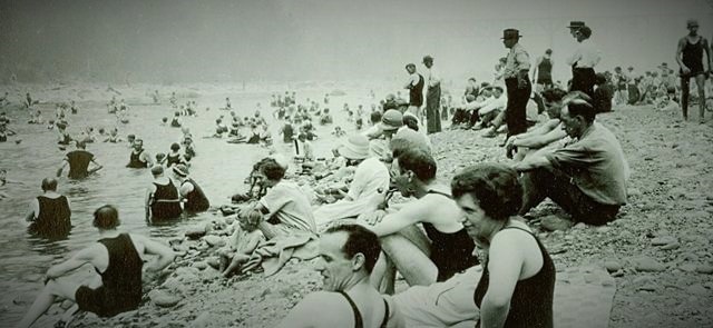
“I imagine you’ll be bored with it before the path runs out.” He also told us to google “Dodge Park” when we got home–like I needed to be told that–and we’d find an image from 1920-something of so many folks on the river that there’s hardly space to sit. I had already seen the image on portland.com when I was doing some preliminary research for the outing, but you don’t learn much by shouting out that you already know.
He told me of the train that used to bring Portlanders to picnic on the weekend, a trolley beginning in Montavilla that made 30 stops on the way, and made 30 communities in the process, and ended at the powerstation just upriver of the confluence and Roslyn Lake that was created in the process.
At this point, I don’t remember how much of this story comes from the gentleman and his boxer, how much is the internet version of Portland, how much is the always infinitely helpful pdxhistory.com, the wikipedia page for Bull Run, the google satellite image of the area, or one of the various other tabs open on my computer or in my brain. Of course I could parse it all out but that would be boring and it’s just a figure of speech anyway. This is a space of intersections anyhow, this place where civilization meets nature, the former end of the railroad, the beginning of the pipeline that would lubricate the rapid growth of Portland in the years surrounding the Lewis & Clark Exposition of 1905, this destination for Portland picnickers who wanted to come see where their pristine water source tumbled from the mountains into the meadows to where cattle had escaped the first waves of American settlement. Hence, Bull Run.
Can you name a single thing that Benjamin Harrison did as President of the United States? Did you even know President Harrison’s name was Benjamin? You query, was it not William Henry? If you asked me these questions a minute ago I would have said, no I cannot name anything he did, and, yeah, wasn’t his name William Henry? So I’m not being patronizing when I say Benjamin Harrison, Bill’s grandson, was a second President Harrison who served a single term from 1889-1893 as the meat in a Grover Cleveland sandwich. We’ve all learned something together, and here’s one thing I now know about the 2nd President Harrison other than that he exists: in 1892 he created the Bull Run Reserve by presidential proclamation, thereby preserving the pristine nature of the watershed. Anything else to add, wikipedia?
Wikipedia: Harrison also “facilitated the creation of the National Forests through an amendment to the Land Revision Act of 1891.” Fantastic!
What other connections between the old Bull Run Park and the city of Portland could possibly be made, beyond the literally named Conduits 1 & 2 that convey the water from one place to another, shuttling the commodity underground from one reservoir to the other, causing simultaneous development of parallel infrastructure? Would you call me crazy if at both ends of these conduits–though, granted, Dodge Park is a few clicks downriver from the actual origin of Portland’s water–there were shrines that exist constructed in turn-of-the-20th-century alcoves?

Or how about that the bridge spanning the Sandy was the eastern flank of the original Burnside Bridge, dismantled and transported part by part to the foothills of Mt. Hood?
Because these are facts!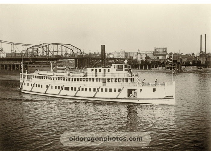
The original Burnside Bridge, opened in 1894, was a swing-span bridge, meaning its 3 sections were essentially independent, and the middle one rotated 90 degrees to let ships through. So, if I’ve got my facts straight, and I’m looking at the picture right, that stretch visible in the above photo is the static eastern third which now connects present-day Portland picnickers with Dodge Park. Furthermore, another section of the bridge was moved over the Bull Run River to connect the powerhouse to the then town of Bull Run, and the last third was sold to Aberdeen. Maybe Kurt Cobain slept under it. That would be nuts.
I read Christopher W. Wells’ Car Country this past month and his analysis of the simultaneity of development at the dawn of the automobile age is fresh in my mind. He noted that the influence of cars was not just felt on the roads where these machines suddenly rumbled in ever increasing numbers, or the factories where they were built, but in settlements that Henry Ford built in the Upper Peninsula of Michigan to produce the wood components for his cars, and Fordlandia in Brazil established in 1928 to source rubber for his cars, and to the furthest stretches of what was named wilderness as more and more roads gave public, easy access to formerly prohibitive terrain. The meaning of nature changed from weather to scenery.
And so the industrial manipulation of Bull Run, and the resulting tourist destination at its confluence with the Sandy, paralleled the settlement along the confluence of those larger rivers the Willamette and the Columbia. Instead of taking the train with trunks of everything you own and choosing a dwelling within the developing grid of Portland, suddenly now spreading on both sides of the river, the picnickers take a trolley with just enough supplies to establish a brief colonization on the banks of the river, or they purchased such supplies from the Bull Run store, their day at the river like a generation of settlement wiped out by the passage of time.
We walked along the railroad easement until it brought us out of the Sandy’s little gorge, surely to where old tracks met the wooden trestles of the original bridge, and found the no trespassing signs that the man with the boxer said we would find but were encouraged to ignore. It was getting dark anyway so we went back and looked along the bank of the river, finding what the man had referred to as the big party spot in the summer. We told Emily the plot of the first 6 Star Wars movies because she was going to see the 7th one when we returned to the city.
“Alright, so, a long time ago, in a galaxy far, far away…”
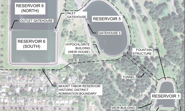
We didn’t have anything to leave in the shrine, but I can remember to bring an item to the shrine in Mt. Tabor’s Reservoir #1, where Conduit #1 shepherds the pristine waters of the Bull Run to the people of Portland.
It is labeled below as “fountain structure” and elsewhere in the Mt. Tabor Historic Report as “small drinking fountain object on the north,” but it is nothing other than a place of spiritual power, a shrine to a moment when nature and civilization fused in the service of the people.

During this time the(they) built…. Nicely done
Sent from my iPad
>
Got it! Thanks!